Since I was a kid I’ve been a real history buff. Of course, much of history, like a good novel, is character-driven; and my two all-time favorites from American history are Mark Twain and Ben Franklin. Like most, I admire Twain for his irreverent wit. Franklin, on the other hand, I admire because of every aspect of his life. A truly self-made — and educated — man, he rose from humble origins to become one of the most important figures of his day not only in America, but in the entire world. Of course, Americans most know old Ben only as one of our founding fathers. But my admiration stems as much from his scientific prowess as his political. He was the most famous scientist of his time, and his list of discoveries, accomplishments and inventions is truly astounding. (What can you say about a guy who both helped explain electricity and suggested daylight-saving time?)
While many know of his famous experiment with lightning, few know that Franklin the scientist was also America’s first oceanographer. He “made his bones,” as they say, in marine science by way of the Gulf Stream. In fact, he’s credited for naming it. Yet, Franklin’s interest in the Gulf Stream was not spurred initially by science. Among other duties, aside from helping to found the American Republic, Franklin was also our first deputy postmaster general.
Over his lifetime Franklin spent several years in England, and crossed the Atlantic many times. His interest in the Gulf Stream emerged after receiving complaints that westward mail from Europe to America took weeks longer than the eastbound ships. This, of course, was a major concern for anyone responsible for mail delivery. A Nantucket whaler and Franklin relative, Timothy Folger, explained to him that the eastbound ships had to buck an incredibly strong and permanent current — a literal river in the sea. That’s when Franklin, the scientist, went to work.
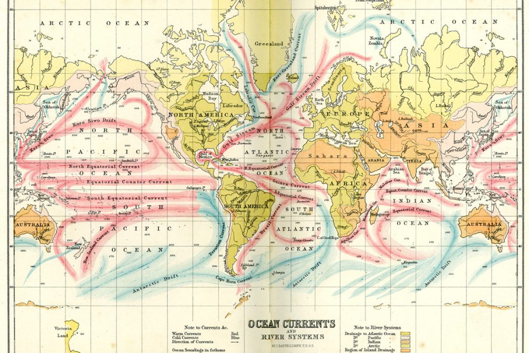
During at least three of his trans-Atlantic voyages, Franklin took water temperature measurements and recorded his observations as accurately as possible on charts. He also determined that, because of the shallower water, the western bank of the Gulf Stream is significantly cooler than the eastern bank. Eventually, using his data, he could determine whether a vessel was in or out of what he termed the “Gulf Stream.” And knowing this allowed one to estimate a ship’s proximity to the American coast. What’s amazing is that, while a full understanding of why the Gulf Stream exists didn’t arise until after World War II, the great man’s theory, it turns out, was very much on track. He wrote, “This Stream is probably generated by the accumulation of water on the eastern coast of America between the tropics, by the trade winds that constantly blow there.” He even reasoned that the speed gradually slowed as it flowed north, but was still strong enough to bring relatively warm water well into the North Atlantic. Based on his extensive observations, Franklin published a chart in 1769 to assist ships in avoiding the Gulf Stream on their westward voyages.
Although Franklin gave this massive current its name, the Gulf Stream actually has little to do with the Gulf of Mexico. Of course, over the centuries Franklin’s crude chart has been replaced by sophisticated satellite images, sea-based observations and computer analyses which take into account factors such as sea bottom topography, seasonality, the gravitational influence of the moon and surface wind effects. Still, while the Gulf Stream meanders and spins off eddies, making its course somewhat erratic, it has maintained its steady northwestern path since the closure of the Isthmus of Panama nearly 5 million years ago.
Before Ben
Although Franklin gets the glory for naming the Gulf Stream, it was known by mariners centuries before him. Some think that it may even have had a more significant effect on western history than we realized.
The first historical record of the Gulf Stream appears to have come from a voyage of Conquistador Ponce de Leon, of the Fountain of Youth fame. A logbook account of one of his voyages from April 22, 1513, notes, “A current such that, although they had great wind, they could not proceed forward, but backward and it seems that they were proceeding well; at the end it was known that the current was more powerful than the wind.” The chief pilot on this voyage was one Anton de Alaminos, who six years later sailed from Vera Cruz, Mexico, to Spain following the Gulf Stream. Anton de Alaminos was quite an accomplished navigator, having also sailed with Columbus on his last voyage. So, many maintain that Alaminos deserves credit for discovering the Gulf Stream, since he was the first to take full advantage of it.
Regardless of who first discovered it, we probably owe many of the famous shipwrecks that sprinkle the path of the Gulf Stream to the conqueror of the Aztecs, Hernan Cortez. He was the first to send large numbers of gold- and silver-laden ships from Mexico through the treacherous Florida Straits, and northeastward following the Gulf Stream’s clockwise motion toward Europe. Today museums from the Florida Keys, up the U.S. east coast and on to Bermuda are filled with relicts from unsuccessful voyages using the famous Gulf Stream as a path.
Yet, the importance of the Gulf Stream doesn’t end in the New World. It had as much, if not more influence, on European history. In fact, some historians today believe that it’s because of the Gulf Stream that England ruled the sea and colonized much of North America; and had it not been for the Gulf Stream, most North Americans might be Spanish-speaking Catholics. The reason is because of a lesson we all sat through in high school world history — the 1588 defeat of the Spanish Armada. At the time Spain boasted the most powerful navy in the world, and held unquestioned dominance over the sea. Then, because of lust and the lack of a male heir, Henry VIII brought a new religion to England. So, at the urging of the pope, Spain went to war with England to restore the Catholic faith to heretical England. To make a long story short, superior armament, better vessel maneuverability and superior tactics enabled the much smaller English navy to fight the Spanish juggernaut to a tie. Due to unfavorable winds and pesky English sailors, the Spanish were forced to withdraw by sailing all the way around the northern British Isles and out to open sea to return to Spain.
As history tells us, more than most of the armada didn’t make it home, and the reason most historians cite is the misfortune of bad weather. A series of storms and rough seas, they say, caused the Spanish fleet to be dashed on the rocky shores of western Scotland and Ireland. But after more careful analysis of the historical record — and the weather forecast — some historians dispute the claim that either bad weather or bad seamanship was responsible for loss of the fleet. Along with the most powerful navy in the world, the Spanish also had some of the best seamen and navigators. And they certainly knew how to sail ships in storms. So why did the ships end up on the rocks? Recent evidence points to the Gulf Stream. But how could an ocean current cause a fundamental reshuffling of western politics and history?
While seafarers had known about the existence of the Gulf Stream decades before 1588, they never imagined that it flowed all the way to Britain. (We now know it flows well past Britain and on to the coast of Norway north of the Arctic Circle.) So, the theory goes, in calculating their westward progress toward open sea, navigators failed to recognize that they were fighting this strong current. As a result, the fleet made its southward turn much too early to clear the Scottish and Irish coasts. Spain never recovered from the devastating and humiliating defeat, and England began its rise to eventual global domination of the sea, making the British Empire possible. All of this because of an ocean current.
Post-Franklin
After Franklin, few gave the Gulf Stream much study or consideration, which is surprising given its effect on shipping. It wasn’t until 1845 that Alexander Dallas, of the U.S. Coastal Survey, resumed the Great Man’s task of making detailed observations. But perhaps the most eloquent description of the Gulf Stream was written in 1855 by a U.S. naval officer and father of physical oceanography, Commander Matthew Fontaine Maury. “There is a river in the ocean.” wrote Maury, “In the severest droughts it never fails, and in the mightiest floods it never overflows. Its banks and its bottoms are of cold water, while its currents are warm. The Gulf of Mexico is its fountain and its mouth is in the Arctic Seas. It is the Gulf Stream. There is in the world no other such majestic flow of waters. Its current is more rapid than the Mississippi or the Amazon.”
Indeed, Maury was right about this mighty oceanic river. It begins as part of a clockwise-rotating system of currents in the North Atlantic, called the North Equatorial Current, which flows westward off the coast of northern Africa. Off the coast of South America, the North Equatorial Current forks into two branches: One passes into the Caribbean, the other flows north and east of the West Indies. The two branches rejoin and pour through the Straits of Florida at an incredible rate of 30 million cubic meters (the volume of 15 Superdomes) per second to become the Gulf Stream. The amount of flow water involved in this system is mind-boggling. By comparison, all of the rivers that empty into the Atlantic, including the Mississippi and Amazon, amount to a paltry 0.6 million cubic meters per second. The geography of the Florida Peninsula brings the Gulf Stream closer to Palm Beach County, Florida, than any other continental landmass. This close proximity, combined with the speed of its relatively pristine waters, are what make this area the most famous drift diving destination in the world.
Along its journey the Gulf Stream is remarkable in just how much it affects life on earth. For instance, its warm waters are what enable the coral reefs of Florida, the Bahamas and Bermuda to exist outside the boundaries of the Tropic of Cancer. (Bermuda is at the same latitude as North Carolina.) Its meandering allows tropical species such as angelfishes and butterflyfishes to survive as far north as Long Island and southern New England during summer. It moderates the climate of Europe, bringing mild winters to Britain and north Europe (which are at the same latitude as Canada’s iceberg-infested province of Labrador). It even enables the Norwegian islands of Lofoten, located well above the Arctic Circle, to remain ice-free all winter while ports far to the south are frozen in for months. Without this vast heat pump called the Gulf Stream — with the power generation comparable to that of a million nuclear power plants — Europe’s average temperature would drop 9-18 degrees Fahrenheit (5-10 degrees Celsius), with similar results in eastern North America.
OK, So Why?
What makes the Gulf Stream tick are the same forces that drive all of the great surface currents of the world’s oceans. These forces include wind, thermal expansion and contraction of seawater and differences in density between water layers. In addition, there’s gravity, friction, pressure gradients, the shape of the ocean basin in which the current circulates and the mysterious Coriolis effect.
The most important factor that drives surface currents is surface winds. Most of Earth’s surface wind energy is concentrated in bands of winds termed the trade winds (which blow eastward) and the westerlies. As wind blows across the sea surface, it transfers some of its energy to the water by friction. A general rule is that the friction of wind blowing for at least 10 hours will cause surface water to flow downwind at about 2 percent of the wind speed.
Because ocean currents eventually encounter a continent (except in the southern ocean where it completely circumnavigates Antarctica), the moving water piles up in the leeward ocean basin. This means that the height of the water column will be higher on the “piled up” side of the basin, and gravity will act to pull the water back down the slope in the direction it came. But, rather than simply moving back and forth in response to the force of wind versus gravity, the Coriolis effect causes the flow to be deflected clockwise (in the Northern Hemisphere). Continents and other topographic features on the sea bottom deflect the moving water into a circular pattern known as a gyre (a Greek word meaning “circle”). The Gulf Stream is the most powerful segment of the North Atlantic Gyre.
RELATED READ: STUDY INDICATES GREAT PACIFIC GARBAGE PATCH GYRE IS GROWING
As a result of this spinning gyre, a literal “hill” of water develops near the center of the North Atlantic. Although just a few meters in height, this hill can be detected by satellite imagery. In fact, the sea surface in general possesses a very distinct, though transient, topography. It warps into expansive mounds and depressions, like the hills and valleys you might encounter if you walked across a rolling pasture. The hills are caused by converging currents piling the sea surface upward, while the valleys are the result of diverging currents caused by the water moving apart.
While the height differences between the sea’s hills and valleys rarely differ by more than a meter or so, they have tremendous influence on the circulation of surface currents. The reason is because of the development of pressure gradients. These gradients arise as a consequence of the horizontal variation in the height of the water surface (the hills and valleys). Specifically, water piled up in a hill creates a zone of high pressure, due to an increase in the height of the water column. In response, water flows down the pressure gradient. The steeper the pressure gradient, the faster the water will flow, just as a ball will roll down a steeper slope faster than a gentle one.
As the gigantic gyre of the North Atlantic makes its way around its circuit, the converging flow forms its “hill” of water about 6.5 feet (2 m) high (as seen in Figure 1). This hill is centered near the middle of the Atlantic in the area of the Sargasso Sea, and is maintained by unceasing wind energy. The hill also explains, in part, the movement of a particle of water, labeled B in Figure 2. It cannot continue turning to the right because it would have to move uphill against gravity and the pressure gradient. But it also cannot move left because that would defy the Coriolis effect. The only option is to continue westward and then clockwise around the entire Atlantic gyre. Imagine this happening to all of the particles within the gyre and one can begin to comprehend the dynamic balance between the downhill force of the pressure gradient and the uphill tendency of the Coriolis deflection. (This is what’s termed a geostrophic or “earth turning” current.)
The Gulf Stream is not only swift, it’s also deep. Its waters reach 1,500 feet (450 m) of depth as it passes the south Florida coast at an average rate of 5 mph (8 kmph). This high-speed characteristic of surface current in the western boundary is common in all ocean basins.
Like all currents on the western side of ocean basins, the Gulf Stream is much stronger than the Canary Current of the eastern north Atlantic. The reason is quite complex, and some of the explanation is beyond the scope of this discussion. However, the “Cliff’s Notes” version goes something like this: Note from Figure 2 that the north and south trade winds straddle the equator, and their combined effect causes currents along the equator to converge. This concentrates and pushes water toward the west where it “piles up” at the western edge of the ocean basin before quickly returning poleward. Here’s where the famous Coriolis effect intercedes.
As the current moves toward the poles, the Coriolis effect increases. (The Coriolis effect is greatest at the poles and zero on the equator.) In the North Atlantic, the Earth’s rotation pushes the “hill” of water toward the western basin, making it steeper on that side compared with the eastern side. This steeper angle increases the pressure gradient on the western side as well. The result is that the increasing tendency of the Coriolis effect to turn the water to the right is balanced by the stronger pressure gradient, thus increasing the speed as the current flows north.
The intensification also increases because, as the hill is pushed westward, water must squeeze closer to the western boundary to pass. The combined effect of these phenomena, as well as a few that are too complex for the scope of this article, result in what is termed as “western intensification.”
The exact opposite phenomenon occurs to the east. As you see from Figure 2, the westerlies in each hemisphere are widely separated, and do not converge as do the trade winds. So, the water driven by the westerlies is not concentrated along a line of convergence as happens at the equator. Deflection from the Coriolis effect can also move some of the eastbound water toward the equator before reaching the eastern boundary of the basin, thus dissipating some of the intensity of the current flow.
The next time you find yourself in southeast Florida, or in the Florida Keys, staring out to sea after a great — or not so great — day of diving, remember that you’re looking at one of the largest, most significant and in some ways most romantic physical phenomenon in the entire Atlantic: the Gulf Stream.
When a Straight Line Isn’t a Straight Line
What exactly is this Coriolis effect that we hear so much about? Named for Gaspar Gustave de Coriolis, the Frenchman who worked out the mathematics, the effect explains the motion of an object in a rotating system. As it relates to the Earth’s movement — geophysics — it explains the lateral displacement of a north-south moving object (clockwise in the northern hemisphere and counterclockwise in the southern hemisphere). If you want to see the effect in action, and you have a globe of the Earth, try this: Spin the globe in an eastward direction (like the way the Earth turns). As it’s spinning, take an erasable marker and attempt to draw a straight line from the North Pole to the equator. (It’s easiest if you use the globe’s support bar containing the latitude scale as a straight edge.) Note that even though the line you drew was straight, the mark on the globe curves clockwise. If you repeat the exercise starting from the South Pole, the line deviates to the left (counterclockwise). The same thing happens to water, air or any object not in contact with the ground as it moves over the Earth.