The chance of finding Spanish treasure is one of the bonuses of diving in many places along Florida’s coast. In fact, a few people have become wealthy diving for gold, silver and jewels recovered from the sites of wrecked Spanish ships. Anyone who finds even a single 16th-century coin can thank Mother Nature, especially the wind. The extreme winds of hurricanes and the waves they kick up sank most of the ships from three different Spanish fleets along different parts of Florida’s Coast.
A storm in 1622 left ships scattered on the bottom of the ocean from Dry Tortugas east to the middle part of the Florida Keys. In 1715 a hurricane sank treasure ships along the southeastern Florida Coast. Then in 1733 a hurricane destroyed a third treasure fleet along the Upper Keys. Not only did hurricane winds and waves sink these fleets and numerous other ships carrying treasure back to Spain, global wind and ocean current patterns brought these treasure ships to the oceans near the Florida Keys and the East Coast. While we don’t depend on the wind to propel our ships and boats as sailors did until well into the 19th century, the winds still help determine the best places to go diving and which days will be good for venturing into the water.

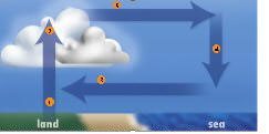
Figure 1: Simplified global wind patterns 1. Air rises in the tropics. (red arrows) 2. Air flows toward the poles and sinks. (green arrows) 3. Descending air creates mostly clear skies, light winds in Horse Latitudes. (the yellow belts around the globe) 4. Some of the descending air flows back toward the equator as the trade winds. (purple arrows) 5. Some of the descending air becomes the mid-latitude westerlies. (blue arrows)
Where Does the Wind Come From?
Wind begins with the unequal heating of the Earth’s surface — sometimes directly, sometimes indirectly. Air begins moving to create wind when the pressure of the air is higher in some places than in others. Air begins moving from areas of high pressure toward areas of low pressure. Once it begins moving, various forces come into play. The Earth’s rotation, friction with the surface and centrifugal force all work with the force created by air pressure differences to determine the wind’s direction and speed. Sometimes the sun’s heat directly creates the pressure differences by heating air and causing it to rise. As air rises from the surface, the pressure at the surface decreases, creating an area of low pressure.
Often, areas of high and low air pressure are created by the movements of upper air winds. For example, where winds converge or come together high above the Earth, some air is forced down to create an area of high pressure at the surface. When the wind aloft diverges, or spreads out, air rises to replace the diverging air, and an area of low pressure forms at the surface.
The global-scale winds that helped bring Spanish treasure ships and hurricanes to Florida’s coasts begin with the year-round solar heating of the land and oceans in the tropical regions on both sides of the equator around the globe. The land and oceans soak up the heat and warm the air right above the ocean and the ground. As the air warms, it becomes less dense — or gets lighter — and begins rising. Water vapor in the rising air condenses to form the towering clouds with showers and thunderstorms that are typical of the tropics.
After rising 20,000 feet/6,096 m or more above the ocean, the air flows north and south, away from the equator. It eventually sinks around 30 degrees north and south latitude. The air sinks because it cools and also because air flowing away from the equator converges. A look at a globe will show you why. Imagine winds blowing along the lines of longitude that run north and south to converge at the north and south poles. Air that stretched 60 nautical miles between each degree of longitude at the equator would be squeezed into space only inches between each degree of longitude if the wind made it almost to the north or south pole.
Sinking air doesn’t just form areas of high pressure at the surface; it also warms up. This keeps clouds from forming, which is why most of the world’s large deserts are in the regions of sinking air around 30 degrees north and south latitude. Back in the tropics, air is flowing in to replace the rising air, creating winds along the surface, especially over the oceans where there is less friction to slow the wind than over land. Some of the air that’s sinking far to the north and south becomes part of the flow back into the tropics.
If the Earth were standing still, the winds at the surface would be blowing directly toward the equator, that is, to the south in the Northern Hemisphere and to the north in the Southern Hemisphere. But the Earth’s rotation turns Northern Hemisphere winds to the right and Southern Hemisphere winds to the left. This creates “trade winds” that blow from the northeast on the north side of the equator and the southeast on the south side. They are called “trade winds” because captains of early sailing ships could count on them for westbound trips. Trade winds carried Spanish ships to the Caribbean, Mexico, and Central and South America with goods to be traded for the treasure of the New World.

Getting back to Spain with the treasure required taking advantage of the more complicated wind patterns of the middle latitudes, the area of the globe between about 30 degrees and the polar regions. While some of the air that’s sinking at around 30 degrees latitude is blowing back toward the equator, the rest is flowing toward the poles. Since winds turn right in the Northern Hemisphere and left in the Southern Hemisphere, these middle-latitude winds end up blowing pretty much from the west in both the Northern and Southern hemispheres. Figure 1 is a simplified view of the major global winds. To return to Spain, the treasure ships had to sail far enough north — to the coasts of what are now South and North Carolina — to catch the westerly winds that would take them back to Europe.
The area of sinking air slows the progress of sailing ships because the air is sinking very slowly, which means the winds at the Earth’s surface tend to be light and unsteady. Sailors used to call this region of the globe around 30 degrees north and south the “horse latitudes,” apparently because people on becalmed ships might be forced to use the horses on board for food or throw them overboard as grain and water supplies dwindled.
There is another area of generally calm winds, where the trade winds converge and where air is rising along the equator, known as the doldrums. Fortunately, the Spanish treasure ships had a generally reliable route across the horse latitudes, except when a hurricane happened to catch them. The treasure ships and the war ships that protected them would gather in Havana and sailed north to catch the strong current that flows out of the Gulf of Mexico between the Florida Keys and Cuba. The ships would then catch a ride in the Gulf Stream between Florida and the shallow waters of the Bahamas, all the way north to the winds that would carry them back to Spain.
Winds and Weather
The Gulf Stream and other ocean currents are caused in part by global winds. The water that flows between Florida and Cuba and then north had
originally been pushed into the Caribbean Sea and the Gulf of Mexico by the northeastern trade winds. Along with making the Florida Keys and East Coast great places for treasure diving, global winds go a long way toward determining the best vacation destinations and the best times of the year to visit.
Monsoon winds, for example, create wet and dry seasons in many parts of the world. Most of the time, most people would prefer to take diving or other vacation trips to these places during the dry season. The word “monsoon” often refers to the heavy rain during the wet season or even to the wet season itself. Meteorologists use the word “monsoonal” to define a climate with distinct wet and dry seasons caused by regular switches in wind direction.
In Asia, for instance, inland areas heat up much more quickly than the oceans in the summer. As the ground warms over areas such as the highlands of Tibet, the heated air begins rising and humid air from the ocean begins flowing inland. The flow increases as the summer goes on. As the humid winds blow inland and uphill, the air is cooled and the air’s humidity condenses into clouds and downpours.
During the winter, inland areas cool rapidly and the cool, dry air, which is heavier than warm, humid air, begins flowing toward and over the oceans.
Bombay, India, is an extreme example of a place with a monsoonal climate. From December through April, no rain falls — the average rainfall for each month is zero. But July averages 25.6 inches/65.6 cm, and the four months of June through September average 81.1 inches/207.9 cm. The other three months, May, October and November, combined average only 4.2 inches/10.8 cm of rain.
Anyone who’s planning a dive trip to Australia’s Great Barrier Reef should know that the wet season there is during the Land Down Under’s warm season — November through March — when it’s chilly in the Northern Hemisphere. Fortunately, it’s not as wet as Bombay. During March, the wettest month on average, Cairns, Australia, averages 17 inches/44 cm of rain, while August averages only .9 inches/2.3 cm.
By the way, Cairns, one of the largest cities along Australia’s northeast coast where the Great Barrier Reef is located, is in the tropics, which means it doesn’t get cold in the winter. In August the average high and low are 83˚F/28˚C and 63˚F/17˚C, while the March averages are 87˚F/17˚C and 73˚F/23˚C, with higher humidity.
Winds can make a big difference in rainfall for places that don’t have monsoonal climates, especially on tropical islands with mountains. Hawaii offers a good example. Most of the time, the trade winds blow from the northeast across Hawaii’s islands. Mountains on the east sides of the islands have heavy rain. The higher you go, the heavier the rain. In Hilo, for example, which is on the eastern side of the Big Island, about 130 inches/333 cm of rain fall each year near the ocean, but about 200 inches/513 cm fall only 6 miles/10 km away in the mountains. Honolulu, which is on the southern side of Oahu, sheltered by the mountains from the trade winds, averages only 22.4 inches/57 cm of rain a year.
Local sea breezes, which make places near the ocean or a large lake more comfortable during the summer, work much like monsoons, but on a much smaller scale. As land heats up during the day, air begins rising and cooler air begins flowing in from the ocean to replace it. By afternoon places right along the ocean might be 10˚F/6˚C cooler, thanks to the sea breeze, than places only 10 or 15 miles/16 or 26 km inland.
Anyone going out in a boat should expect the wind to grow stronger during the afternoon on a sunny day. Often the rising air will form a line of clouds a few miles inland called the “sea breeze front.” These clouds sometimes grow into showers and thunderstorms. Sea breezes (Figure 2), not a monsoonal climate, make summer the rainy season in Florida and also make the central part of the state, roughly from Tampa Bay to Cape Canaveral on the East Coast, the “lightning capital” of the United States.
Sea breezes from the Gulf of Mexico and the Atlantic converge over the middle of the state when conditions are right. This creates thunderstorms with frequent lightning and downpours.
Air flowing downhill can create unique weather conditions. Just like air descending to create high pressure at the surface, air that flows downhill is compressed and warmed.
Winter “Chinook” winds of the Rockies sometimes bring spectacular warm-ups to the western plains. These winds are created when strong winds blow over the mountains from the west. As the wind crosses the mountains, it flows downhill, warming at the rate of 5.4˚F/-14.8˚C for each 1,000 feet/305 m it descends.
As an example of what Chinook winds can do, on February 21, 1918, the temperature in Granville, North Dakota, rose from -33˚F/-36˚C in the early morning to 50˚F/10˚C in the afternoon as Chinook winds blew.
California’s “Santa Ana winds” are also caused by air warming up as it descends mountains. The Santa Ana winds come from the inland deserts and turn even hotter and drier as they sweep downhill into the Los Angeles Basin. The winds speed up as they squeeze through canyons. Santa Ana winds can fan wildfires into uncontrollable infernos.
Any kind of wind blowing down a mountain is a “katabatic” wind. Many areas of the world have such winds and also local names for them. One of the best known is the “mistral,” which blows down into the Rhone Valley of France and out over the Mediterranean Sea, where it can put a chill on a vacation along the Riviera.
The west-to-east winds that Spanish treasure ships rode back home to Europe are part of a global system of generally westerly winds in the middle latitudes that blow not only at the Earth’s surface, but also up more than 40,000 feet/12,191 m. The high-altitude winds are the jet streams, which help push storms along, and also bring wintry blasts of cold air and summer heat.
In the tropics, winds at all levels of the atmosphere generally blow from east to west. These winds push Atlantic and eastern Pacific hurricanes, western Pacific typhoons, and Indian Ocean and southern Pacific tropical cyclones from east to west while the storms are in the tropics. As these storms work their way north or south toward the poles, they are picked up by the mid-latitude westerly winds, which push them back toward the east, where they die over the chilly waters of mid-latitude oceans.
If you are ever diving in Florida and happen to find an encrusted gold or silver coin from a Spanish ship, you have not only found a tiny piece of treasure, you have also made a connection with the world’s constantly moving winds, which brought together a fleet of Spanish treasure ships and a hurricane.
By Jack Williams